Saturday, September 18, 2010

San Gorgonio via Vivian creek

With the Cactus to Clouds to Cactus coming up on Oct 9th, a tough
hike was in order.  5am at the ranger station but no permit
available.  I met Edgar and his group from Hollywood.  They
have a permit for 8 but only 5 showed.  I'm In.


From the trail head you climb 1,200' to
Vivian Creek in 1 mile.  From there the trail
mellows out and you can just cruise. 


I hung out with  "Hollywood" to Vivian Creek.
Put in the Ipod and headed out.  Weather is perfect,
55 and clear.


High creek camp in just under 2.5 hours.
I'm supposed to turn around at 4 hours but
it looks like I can make the summit in 4-ish.


Over 10,000' and at least 5 miles from the trail head!
OK, I'm alright with the smoking but the littering...come on.


San Jacinto and a look at the Cactus to Clouds route.

The trail pretty much follows the left ridge.  Start at the museum in
Palm Springs (elevation 700') and hike to the summit (10,634').
Then back down to the tram - about 16 miles and over 10,000'
of elevation gain!. 

Oct 9, no tram.  Add 10 miles and 8,000' of
down.  We'll be starting about 2am.


Just below tree line and I can see a fire came through here.
All of the tree's survived.  


Nearing the summit and looking back
for any signs of the Hollywood gang.  Place is empty.
For no permits being available, where is everybody?
Besides the Hollywood group, I've only
talked to 3 other hikers.


Nice to know that after 4 hours and 8 miles I'm heading
in the right direction.


The summit in view.  It's more of a bump than a 
summit but it is what it is.


8.6 miles in 4 hours and 10 minutes.
Another personal best!


Edgar and the rest of Hollywood!
I'm sure they all made it.  Probably 1.5 hours to go from here.


The trail is in great condition.   I was able to jog
out for a 2 hour and 35 minute exit. 


6 hour 45 minute - 17.2  mile round trip.

Tuesday, September 14, 2010

Me and T on Whitney

Travis called and said he wanted to climb the
Mountaineers route.  It doesn't take much to get me interested
in a Whitney hike so I told him to get his gear ready, I'll be there Friday.
We were at the visitor center by 4:00 and were able to 
get permits.  We headed over to the Pizza Factory
for some of the best pepperoni pizza there is.  Then it was up to
 Tuttle campground - 5,120' - for the night.   

The saying goes "Sleep low - climb high".


I've always liked Tuttle.  It's $5.00 a night with
clean bathrooms, only 3 1/2 miles from
trail head, and nobody is ever there.


We got a 5:30 am start and were at the ledges as the sun came up.


The climb above the ledges heading to Lower Boy Scout lake.
This is where you start asking yourself "why am I doing this?" 


Someone has put a lot of work into these cairns.  They
really make it easy to follow the trail, at least
up to Iceberg Lake.


Pounding up the slabs.


Travis with the chute behind him. 
We're ready for the real climb to begin but 1st we
needed to filter some water at Iceberg lake.  That's 
where we picked up Craig.  His climbing partner was sick and
needed to descend.  He really wanted to summit
so he came with us.


The climbing is pretty cool all of the way up the chute. 


A view up the east buttress. 

We go up and fade right into the chute.


A quick water break, 10 minutes to the notch.


Craig - happy to be past the scree.


That 1st move into the North Face is a little tricky.


Half way up the final 400.  Lunch. is waiting.


Up the final chimney to the top. 


A look back down.


The summit pic!  Well done.


Me and T at the notch ready for the trip back down. 
It's a real butt kicker - maybe harder than the up. 

We ended up getting back to the trail head at 5:15 - another
12 hour Whitney hike.  This was both Travis and Craig's
1st Whitney hike and they started with the
Mountaineers route.  Sweet!
  It couldn't have been any better of a day!

Tuesday, September 7, 2010

Mt Ogden and Snowbasin - Labor day 2010


 Trail head - 5,100
Difficulty - Strenuous
Length - 5.5 miles one way - 3.5 hours
Elevation gain - 4,500'
Weather - 37 and breezy at 7am


So overgrown you can hear the water but can't see a creek.  
Really lush and green for September. 


2 miles in and the trail heads away from the creek and UP. 
I met Tony and Margaret (both in their 70's) about 2.5 miles in. 
Tony hikes everyday and catches this trail to Snowbasin
every weekend - the lift operators know him by name. 
Amazing!


Very overgrown and steep.  Branches constantly catching my
shirt, shoelaces. I should have wore pants instead of shorts. It's skinny and steep.
A trip here could be a disaster.


Finally I get above the brush.  
The trail is much easier to follow but it's a steep climb.
Light breeze with temps hanging about 50.
Chilly but nice hiking weather.


Finally, Mt Ogden. 


The final climbs a little sketchy.   


Pineview reservoir with Powder Mountain in the background.


Whoever has the job to land a helicopter on this dime size helipad
has got to be crazy.  Sheer drops on 3 sides with a large antenna on the other.


On the summit I met Matt, the only other person to make it
that morning.  He convinced me to follow his group over to Snowbasin ski
resort and ride the gondola down (free going down but it' like $14 to ride up). 
They shuttled a couple cars over last night for the return trip.
He thought it would be brutal to go back the way we came up.
No disagreement there.


You're supposed to climb up and follow the ridge.  A couple of Matt's group
didn't summit and went the wrong way.  Now they need to climb back up.  


They didn't get up to the ridge but tried to traverse across.
They ended up making quite an adventurous detour.


The dog must be part billy goat. 
She was calm the whole climb like
it was a walk in the park.


The trail over to Snowbasin.


A last look west at the Great Salt Lake before dropping
down into Snowbasin.  You can see our trail up 
just below center.


Snowbasin.  This place is huge.


The near vertical east face of Mt Ogden from the gondola. 

They actually let the dog ride down, against the rules.  Otherwise it was
a 4 mile walk down to the parking lot.


They weren't as easy going with my hat. 
They said it had to go or I could walk the 4 miles. 
Man I loved that hat!


Sunday, September 5, 2010

Etiquette on the North Face of Whitney


I was heading to Utah and decided to include a Whitney hike in my travel plans. 
Got to the visitor center at 5:15 and was able to get a permit for the next day, August 21st.  


Typical afternoon weather on Whitney.


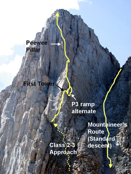
I 'm hiking the main trail to the summit and then down the mountaineers route.


 Got started at 3am - really dark morning, no moon at all. 
Solo hiking in the dark - an experience in itself. 


4.5 hours later and i'm at the cables.  Last time I was through here they were leaning out and scary.  It was June and there was still plenty of snow.  I was heading back down and the trail was icy at the top of the cables. You needed take 2 steps down to a little shelf and then down onto an ice coverd landing.  I couldn't reach the cable so I had to just go for it.  Everything worked out but I'll never forget those couple of steps. 


From the top of the switchbacks (trail crest) to the summit is impressive.  All along the west side is above 13,500, really cool.  The hiking is tough though - you've already
hiked 7 miles and gained over 5,000 elevation.   


            Beautiful on top but cold and breezy.  
Spent 1/2 hour eating lunch and getting ready for
the return trip.


Time to head for the north face (1st part of the route back down). I see a group roped up just above the Notch, about 400' down.  I watch for about 5 minutes and they don't make any progress so I start down.  I hear someone yelling for me to wait.  I stop and look but they still aren't making any progress.  I continue to carefully pick my way down , watching the loose rocks.  After the 1st 100' I need to cross over to where I am directly above the group. Turns out it's a professionaly guided group of 6 and the lead person is now having a cow.  She's yelling for me to stop or stay to my left.  That's the wrong way and she has to know that!  Why would she direct me over there?  I continue to carefully climb down.
It's steep, no loose rocks, just little ledges.  I get down to them in just a few minutes and the
leader starts tearing into me about etiquette (who is this broad?).  I'm surprised.
I've been very careful not to knock any rocks down.  I tell her
to "take a chill pill, it's a big mountain..relax". 
This just pisses her off and she keeps blathering about etiquette lessons.
I"m tell her "OK, thank you. I'll  look into that"  (I wanted to say something completely
different but decided to leave it alone).  She order's me (like I'm one of here clients) to wait for them to get past me.  They still haven't moved an inch from the moment I saw them. 
I ignore her and climb around all 6 of them.  They're looking at me like where's your rope? 
I'm looking at them like why are you roped up?  I'm thinking that if you have to rope up
in August on this route then it's over your head....period!  Use the main trail.

Here it is a Saturday in August on one of the busiest routes in the Sierra
and she wants the mountain to herself. 


I drop down the last 100' to the notch and head on down the chute.
 I can see about halfway down, there's a guy sitting in the middle of the chute.
I get down to him to find out he was too tired to make it.
The guide told him to stay right there until they get back.
This is so stupid. Right in the middle of the chute!  It's just loose scree and rock.
You can't climb down without rocks rolling down. This guy is sitting in a bowling alley.


(He's was sitting right on the yellow line to the right of the P in ramp)

I make it down as carefully as possible and find out that he and 4 of his buddies had
NEVER climbed anything before.  All 5 are from the south (elevation = sea level)
and feeling the altitude. They each paid $650 to be guided up this!  
Aren't there some sort of qualifications? 
I guess the qualification is $650. 

They shouldn't have been on that portion of the mountain. 
They had all of the gear but were definitly not comfortable on the north face. 
Oh well, I hope this guy doesn't get nailed by someone else but I gotta go.  
I had a date with a shower and a beer and didn't want to be late.


 The climb out is challenging.
You want to look at the scenery as you hike but you gotta watch every step you take.
It's steep, loose, and rocky, all the way down to the main trail.


.

 The last real obstacle are the ledges. 


Gotta be a little careful on that last portion.


The trail heading into the waterfall.


By now I've forgotten about you know who.   I'm beat.


15 minutes to a $3.00 shower and a ice cold beer! 


So my question  ...Who had the bad etiquette? 

Was it the professional guiding service
that was getting paid $3,250?  A guide who could have
waited 5 minutes for me to pass.  A guide who knew they would encounter this situation but had no idea of what to do.  A guide who showed no respect for anyone but her paying customers. 

Or was it me?

Hopefully I'll never see her again. 


Now to Utah via Bishop, Tonopah,  Ely, Wendover, Ogden and then Powder Mountain.
Empty roads and wide open country.  A far better drive than that damn higfhway 15.